
Offer
Cartography and GIS
Cartography focuses on modeling of spatial information and its visualization while GIS is a system for collection, processing and analysis of digital spatial data.
Terramap through ...
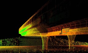
Engineering: surveys, monitoring, modeling
Modern engineering, especially in terms of civil and construction works is based on precise surveying measurements.
Terramap by combining the latest surveying techniques, digital photogrammetry and ...
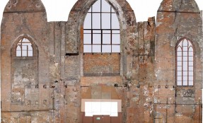
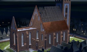
Heritage and architecture
Terramap provides architectural inventory and prepares professional survey documentation. Our team can proof several years of experience in the implementation of national and international heritage documentation ...
Augmented Reality
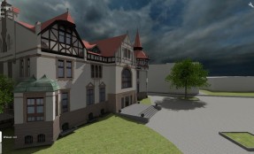
Terramap offers digital three-dimensional modeling based on direct measurements or existing documentation (concepts, maps, technical drawings).
Having 3D model of an object we can virtually change ...
3D Models
We collect (measure) geometry and texture objects of different type and size – from small details (jewelry, sculptures), through buildings up to entire urban units (streets, districts, cities). Continue reading
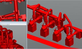
Instalacje przemysłowe
(Polski) Dysponujemy najnowocześniejszymi skanerami naziemnymi, co w połączeniu z tachimetrami elektronicznymi realizującymi pomiary bez sygnalizacji punktów orientacyjnych daje produkt oczekiwany przez zarządzających wszelkimi instalacjami przemysłowymi Continue reading
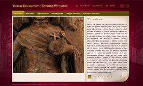
E-Portals
Terramap offers implementation of web portals dedicated for education, information and publicity. Continue reading
Buildings and structures
(Polski) Doświadczona kadra geodetów i fotogrametrów, realizuje najbardziej skomplikowane sieci osnów pomiarowych. Wykorzystujemy do tego m.in. precyzyjne stacje GPS, tak, że wyniki pomiarów mogą być rozpatrywane lokalnie lub globalnie. Continue reading
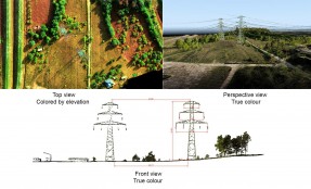
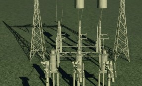
Transmission lines
(Polski) W naszych platformach lotniczych możemy zainstalować różne detektory promieniowania elektromagnetycznego: Dla promieniowania widzialnego przedziale długości fali od 380 do 780 nm to detektorem są kamery video….. Continue reading
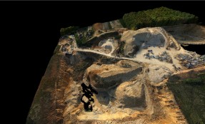
Open-pit and underground mines
(Polski) Nasze technologie pomiarowe sprawdzone w praktyce, dają szybkie wyniki obliczeń objętości i masy składowanych odpadów, hałd węgla oraz innych materiałów. Wykonujemy bilanse robót ziemnych oraz obliczenia objętości mas ziemnych. W pomiarach wykorzystujemy RTK GPS oraz naziemny i lotniczy skaning laserowy….. Continue reading
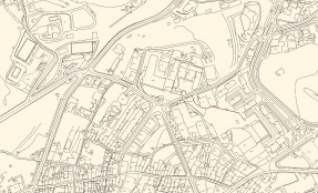
Vector mapping (planimetry)
As a source data for creation of vector maps Terramap uses stereo pairs of aerial photographs, aerial and terrestrial laser scanning, direct surveying or archive raster. Continue reading
Landfills and dumps
(Polski) Wykorzystujemy detektory uczulone na różne pasma promieniowania elektromagnetycznego. Dzięki szczegółowej analizie widma potrafimy ocenić zagrożenia dla środowiska składowanych odpadów, przeanalizować kierunki spływu zanieczyszczeń z składowisk…… Continue reading
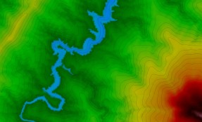
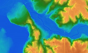
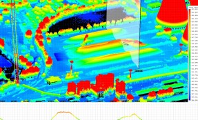
DTM and DSM
Digital Terrain Model (DTM) as digital representation of the portion of the Earth’s surface is the source of a number of geospatial analysis and calculations. Continue reading
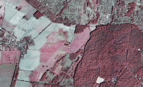
Orthophotomaps
Orthophotomap is generated by mathematical transformation of aerial image into mapform. Camera calibration data , image orientation parameters, terrain height model and ground control points are being used to remove lens distortion… Continue reading